Despite not being able to see the Tetons (cloudy), we did enjoy our journey through Yellowstone. We then enjoyed a very uneventful trip home, arriving at the UofC around 5pm last Saturday.
Thanks for following our trip! Please check out everyone's pictures here:
Utah 2010 Field Camp Picture Albums
Here are a couple pictures from Yellowstone:
Old Faithful (it really did erupt almost exactly every 90 minutes!)
The Grand Canyon of the Yellowstone River (Lower Falls)
The Boys
Hot springs and the Gallatin Mountains
Tuesday, June 22, 2010
Wednesday, June 16, 2010
A nice day in Jackson Hole, WY
Ah, the best laid plans of mice and geology field camps....
Since my last post, the students spent two days mapping the Snake Range (that was planned); we camped in rain, snow, and fog at Wheeler Campground in Great Basin National Park (as planned, but not ideal), and John P. and I spent Sunday in the Ely, NV hospital to fix up his broken pinkie finger (definitely not planned). I'm happy to report that he will make a full recovery!
We returned to Delta late Sunday night to dry out gear and to allow the students to spend Monday working on their final projects in a dry environment. Which of course meant that the weather cleared up at Great Basin as we were leaving. I'm just glad the students got to see the views before we left. I was very sad to leave without the traditional climb to Wheeler Peak.
Wheeler Peak (right) sits at 13, 083 ft. We saw it with *a lot* more snow!
We left Delta on Tuesday and spent last night in Logan, UT. We arrived in Jackson Hole, WY around lunchtime today and everyone had an enjoyable day exploring the town, despite the thunderstorms rolling through. We're hoping for clear weather tomorrow as we travel through Grand Teton NP and into Yellowstone. We will stop at Old Faithful and other classic YNP sights along our way to Madison campground, where we will sleep tomorrow night. Then we'll finish our trek through Yellowstone on Friday morning, arriving in Bozeman, MT for our last night on the road.
Friday, June 11, 2010
Off to Nevada!
Today we leave the Canyon Range and Delta behind. We will be heading west to Great Basin National Park (nearest "town" is Baker, NV). This is one of the last regions of the country without cell service.... there is a pay phone at the Visitor's Center. (I wonder how many of the students have ever used a pay phone before?)
We'll be there until next Wednesday. One more two-day mapping exercise, a one-day cross section through the entire state of Utah, and then the traditional Wheeler Peak Hike & Swim. I'll post pictures once we're back in civilization. Wednesday night will find us near Jackson Hole, WY. We'll head through the Grand Tetons and into Yellowstone, camp in Yellowstone on Thursday night, arrive in Bozeman MT on Friday night and then back in Calgary next Saturday!
These five weeks have just flown by.
Sunday, June 6, 2010
A day off and more pictures
Days off are key for morale and the professor's sanity. The students are off enjoying themselves and I'm enjoying some air conditioning (it's almost 100F right now!) and a high-speed internet connection. We spent the last week mapping in the central Canyon Range and tomorrow will begin a 3-day exercise along the western part of the range. On Friday, we will move out to Great Basin National Park near Baker, Nevada.
So at long last, here are pictures from the trip so far (click on pictures for larger version):
The Canadian Armada headed toward Craters of the Moon, Idaho.
Kyle conquering Angel's Landing in Zion NP
Stephen M., Justin, Erin, Cal, Anthony, Marko, and Josh on the hidden arch in Hidden Canyon, Zion NP
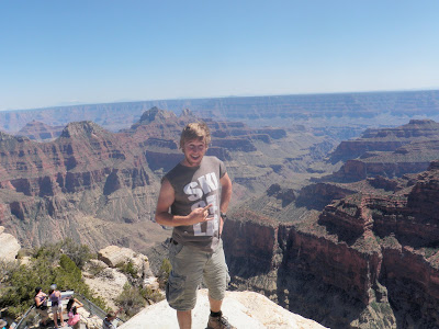
Cody on the North Rim of the Grand Canyon
At Mile Zero of the Colorado River (Lee's Ferry) - where the raft trips begin above the Grand Canyon and where the water temperature is 47F!! Several of us jumped in... I'm still trying to get those pics from "Camera Steve" (Michalchuk).
Monument Valley
An arch not in Arches NP. South of Moab.
The Grand Staircase of the Colorado Plateau (view north from road to Grand Canyon North Rim)
Salt Valley - our 3-day exercise near Moab.
Cal, AJ, and John mapping in Salt Valley.
Kyle (pictured), Cody, Drew, Cal, and Melissa decided to "relax" on our Moab day off with some climbing.
Cody on the Navajo Sandstone
It's very relaxing. Really.
Our camp in the Canyon Range (Fishlake National Forest).
Note the "Cooler Dam" - an excellent natural refrigeration system.
World class geology in the Canyon Range (view to the north)
World class geology in the Canyon Range (view to the south)
Friday, June 4, 2010
Tuesday, June 1, 2010
Canyon Range, near Delta, UT
One of the best things about field camp is the ability to get away from the busy pace of everyday life. This also means that we are in some of the last places in the US that does not have constant cell service. Which can be very nice unless you're trying to upload pictures to a blog, using a less-than-light-speed USB modem.
We have a day off in Delta on June 6. I can promise lots of pictures then.
We have a day off in Delta on June 6. I can promise lots of pictures then.
Sunday, May 30, 2010
Swell!
The San Rafael Swell, that is. Located along I-70 just west of Green River, UT, the swell is a large monocline (half of a fold) that was pushed up by a fault at depth approximately 60-70 million years ago. The students are spending a few hours mapping a small portion of it and I'm sitting on a little hill looking at this:
While on the internet. Technology is amazing. When it's not deleting your blog posts.
While on the internet. Technology is amazing. When it's not deleting your blog posts.
Subscribe to:
Posts (Atom)


